
Thank you for supporting this site ❤️
Make a donation
Make a donation
Mantha topographic map
Click on the map to display elevation.
Thank you for supporting this site ❤️
Make a donation
Make a donation
About this map
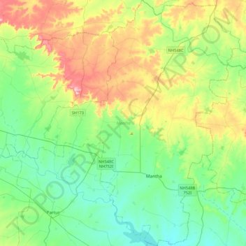
Name: Mantha topographic map, elevation, terrain.
Location: Mantha, Jalna, Maharashtra, India (19.53119 76.19855 19.92855 76.53461)
Average elevation: 488 m
Minimum elevation: 411 m
Maximum elevation: 665 m
Thank you for supporting this site ❤️
Make a donation
Make a donation
Other topographic maps
Click on a map to view its topography, its elevation and its terrain.
Thank you for supporting this site ❤️
Make a donation
Make a donation
Thank you for supporting this site ❤️
Make a donation
Make a donation
Thank you for supporting this site ❤️
Make a donation
Make a donation