
Thank you for supporting this site ❤️
Make a donation
Make a donation
Chisholm topographic map
Click on the map to display elevation.
Thank you for supporting this site ❤️
Make a donation
Make a donation
About this map
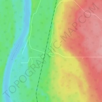
Name: Chisholm topographic map, elevation, terrain.
Average elevation: 608 m
Minimum elevation: 561 m
Maximum elevation: 665 m
Thank you for supporting this site ❤️
Make a donation
Make a donation
Other topographic maps
Click on a map to view its topography, its elevation and its terrain.
Town of Slave Lake
Canada > Alberta > Municipal District of Lesser Slave River
Average elevation: 589 m
Thank you for supporting this site ❤️
Make a donation
Make a donation