
Thank you for supporting this site ❤️
Make a donation
Make a donation
Lambert's Bay topographic map
Click on the map to display elevation.
Thank you for supporting this site ❤️
Make a donation
Make a donation
About this map
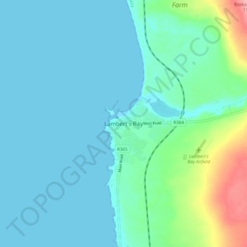
Name: Lambert's Bay topographic map, elevation, terrain.
Average elevation: 19 m
Minimum elevation: 0 m
Maximum elevation: 111 m
Thank you for supporting this site ❤️
Make a donation
Make a donation
Other topographic maps
Click on a map to view its topography, its elevation and its terrain.
Cederberg Ward 1
South Africa > Western Cape > West Coast District Municipality > Cederberg Local Municipality
Average elevation: 690 m
Krom
South Africa > Western Cape > West Coast District Municipality > Cederberg Local Municipality
Average elevation: 870 m
Bulshoek Dam
South Africa > Western Cape > West Coast District Municipality > Cederberg Local Municipality
Average elevation: 184 m