
Make a donation
Anydros topographic map
Click on the map to display elevation.
Make a donation
About this map
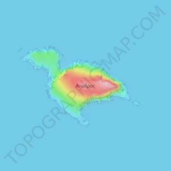
Name: Anydros topographic map, elevation, terrain.
Average elevation: 9 m
Minimum elevation: -1 m
Maximum elevation: 187 m
Make a donation
Other topographic maps
Click on a map to view its topography, its elevation and its terrain.
Make a donation
Naxos
Greece > Aegean > Naxos Regional Unit
Naxos experiences both a Mediterranean climate (Csa) and a hot semi-arid climate (Köppen climate classification: BSh) depending on the location. According to the stations of the National Observatory of Athens, various locations in Naxos have a hot semi-arid climate. Inland areas of the island are much wetter…
Average elevation: 112 m
Make a donation
Ios
Greece > Aegean > Thira Regional Unit
The highest elevation (723 m, 2372 ft) is the Kastro (Greek: Κάστρο) peak also called Pyrgos (Greek: Πύργος), located in the center of the island, while around the Kastro are the next three Highest peaks: Xylodema (Greek: Ξυλόδεμα) (660 m, 2165 ft), Kostiza (Greek: Κοστίζα) (586 m,…
Average elevation: 73 m
Make a donation
Icaria
Greece > Aegean > Ikaria Regional Unit
Ikaria is one of the middle islands of the northern Aegean, 255.303 square kilometres (98.573 sq mi) in area with 102 miles (164 kilometres) of coastline and a population of 8,312 inhabitants. The topography is a contrast between verdant slopes and barren steep rocks. The island is mountainous for the most…
Average elevation: 87 m
Make a donation
Tinos
Greece > Aegean > Tinos Regional Unit
Tinos has a varied landscape. From the shores of Panormos and Kolimbithra on the North Shore to Kionia, Agios Yannis O Portos, and Agios Sostis on the Southern Shore, Tinos has many beaches. Tsiknias is the highest mountain on the island at 750 metres (2,460 feet) and hides the village of Livada. The mountain…
Average elevation: 64 m
Make a donation
Kalymnos
Greece > Aegean > Kalymnos Regional Unit
Kalymnos is mostly mountainous with complicated topography. There are three main chains going from W-NW to E-SE, and a fourth which extends NW the length of the peninsula. The coastline is very irregular, with many sheltered coves. There are some springs, one among them being thermal. The soil is mainly…
Average elevation: 75 m
Make a donation
Make a donation
Tinos
Greece > Aegean > Tinos Regional Unit
Tinos has a varied landscape. From the shores of Panormos and Kolimbithra on the North Shore to Kionia, Agios Yannis O Portos, and Agios Sostis on the Southern Shore, Tinos has many beaches. Tsiknias is the highest mountain on the island at 750 metres (2,460 feet) and hides the village of Livada. The mountain…
Average elevation: 64 m
Make a donation
Icaria
Greece > Aegean > Ikaria Regional Unit
Ikaria is one of the middle islands of the northern Aegean, 255.303 square kilometres (98.573 sq mi) in area with 102 miles (164 kilometres) of coastline and a population of 8,312 inhabitants. The topography is a contrast between verdant slopes and barren steep rocks. The island is mountainous for the most…
Average elevation: 87 m
Make a donation
Tinos
Greece > Aegean > Tinos Regional Unit
Tinos has a varied landscape. From the shores of Panormos and Kolimbithra on the North Shore to Kionia, Agios Yannis O Portos, and Agios Sostis on the Southern Shore, Tinos has many beaches. Tsiknias is the highest mountain on the island at 750 metres (2,460 feet) and hides the village of Livada. The mountain…
Average elevation: 64 m
Make a donation
Naxos
Greece > Aegean > Naxos Regional Unit
Naxos experiences both a Mediterranean climate (Csa) and a hot semi-arid climate (Köppen climate classification: BSh) depending on the location. According to the stations of the National Observatory of Athens, various locations in Naxos have a hot semi-arid climate. Inland areas of the island are much wetter…
Average elevation: 112 m
Make a donation
Kea
Greece > Aegean > Kea-Kythnos Regional Unit
Its capital, Ioulis, is inland at a high altitude (like most ancient Cycladic settlements, for fear of pirates) and is considered quite picturesque. Other major villages of Kea are the port of Korissia and the fishing village of Vourkari. After suffering depopulation for many decades, Kea has been recently…
Average elevation: 81 m
Make a donation
Make a donation
Naxos
Greece > Aegean > Naxos Regional Unit
Naxos experiences both a Mediterranean climate (Csa) and a hot semi-arid climate (Köppen climate classification: BSh) depending on the location. According to the stations of the National Observatory of Athens, various locations in Naxos have a hot semi-arid climate. Inland areas of the island are much wetter…
Average elevation: 112 m
Make a donation
Kolona
Greece > Aegean > Samos Regional Unit > Municipal Unit of Pythagoreio > Ireo
Average elevation: 30 m
Make a donation
Varella
Greece > Aegean > Samos Regional Unit > Municipal Unit of Vathy > Vathy
Average elevation: 146 m
Make a donation
Mykonos
Greece > Aegean > Mykonos Regional Unit > Faros Armenistis
Mykonos (/ˈmɪkənɒs, -noʊs/, UK also /ˈmiːk-/; Greek: Μύκονος [ˈmikonos]) is a Greek island, part of the Cyclades, lying between Tinos, Syros, Paros and Naxos. The island has an area of 85.5 square kilometres (33.0 sq mi) and rises to an elevation of 341 metres (1,119 feet) at its highest point.…
Average elevation: 38 m
Make a donation
Mykonos
Greece > Aegean > Mykonos Regional Unit > Platys Gialos
Mykonos (/ˈmɪkənɒs, -noʊs/, UK also /ˈmiːk-/; Greek: Μύκονος [ˈmikonos]) is a Greek island, part of the Cyclades, lying between Tinos, Syros, Paros and Naxos. The island has an area of 85.5 square kilometres (33.0 sq mi) and rises to an elevation of 341 metres (1,119 feet) at its highest point.…
Average elevation: 38 m
Make a donation
Saria
Greece > Aegean > Karpathos-Kasos Regional Unit > Olympos Municipal Unit
Average elevation: 59 m
Make a donation
Make a donation
Old Port Fira
Greece > Aegean > Thira Regional Unit > Thira Municipal Unit > Fira
Average elevation: 87 m
Make a donation
Make a donation