
Make a donation
Meru topographic map
Click on the map to display elevation.
Make a donation
About this map
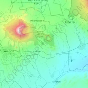
Name: Meru topographic map, elevation, terrain.
Location: Meru, Arusha, Northern Zone, Tanzania (-3.59802 36.74762 -3.05344 37.06524)
Average elevation: 1,342 m
Minimum elevation: 849 m
Maximum elevation: 4,526 m
Make a donation
Other topographic maps
Click on a map to view its topography, its elevation and its terrain.
Mount Meru
Mount Meru is the topographic centerpiece of Arusha National Park. Its fertile slopes rise above the surrounding savanna and support a forest that hosts diverse wildlife, including nearly 400 species of birds, as well as monkeys and leopards.
Average elevation: 3,881 m
Arusha
Despite its proximity to the equator, Arusha's elevation of 1,400 metres (4,600 ft) on the southern slopes of Mount Meru keeps temperatures relatively low and alleviates humidity. Cool dry air is prevalent for much of the year. The temperature typically ranges between 10 and 30 °C (50 and 86 °F) with an…
Average elevation: 1,572 m