
Thank you for supporting this site ❤️
Make a donation
Make a donation
Jerusalem District topographic map
Click on the map to display elevation.
Thank you for supporting this site ❤️
Make a donation
Make a donation
About this map
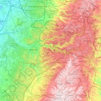
Name: Jerusalem District topographic map, elevation, terrain.
Location: Jerusalem District, Israel (31.60303 34.82024 31.88267 35.26505)
Average elevation: 489 m
Minimum elevation: 54 m
Maximum elevation: 1,015 m
Thank you for supporting this site ❤️
Make a donation
Make a donation
Other topographic maps
Click on a map to view its topography, its elevation and its terrain.
Mount of Beatitudes
Israel > North District > Emek HaYarden Regional Council
The site known as the Mount of Beatitudes is on the northwestern shore of the Sea of Galilee, between Capernaum and the archeological site of Gennesaret (Ginosar), on the southern slopes of the Korazim Plateau. Its negative altitude (around 25 metres below sea level, nearly 200 metres above the Sea of Galilee)…
Average elevation: -128 m
Thank you for supporting this site ❤️
Make a donation
Make a donation