
Ballydesland topographic map
Interactive map
Click on the map to display elevation.
About this map
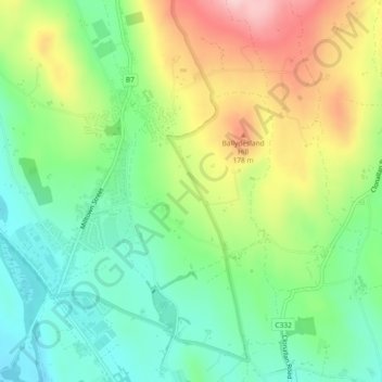
Name: Ballydesland topographic map, elevation, terrain.
Location: Ballydesland, Newry, County Down, Irlande du Nord, Royaume-Uni (54.12046 -6.26072 54.13453 -6.24249)
Average elevation: 93 m
Minimum elevation: 13 m
Maximum elevation: 219 m
Other topographic maps
Click on a map to view its topography, its elevation and its terrain.
Ballyveagh More
Royaume-Uni > Irlande du Nord > Newry
Ballyveagh More, Newry, County Down, Irlande du Nord, Royaume-Uni
Average elevation: 109 m
Ballynagross
Royaume-Uni > Irlande du Nord > Newry
Ballynagross, Newry, County Down, Irlande du Nord, Royaume-Uni
Average elevation: 143 m
Drummiller
Royaume-Uni > Irlande du Nord > Newry
Drummiller, Newry, County Down, Irlande du Nord, Royaume-Uni
Average elevation: 50 m