
Grand River topographic map
Interactive map
Click on the map to display elevation.
About this map
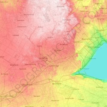
Name: Grand River topographic map, elevation, terrain.
Average elevation: 300 m
Minimum elevation: 70 m
Maximum elevation: 526 m
Other topographic maps
Click on a map to view its topography, its elevation and its terrain.
Hawkesbury
Canadá > Ontario > Hawkesbury
Hawkesbury, Prescott and Russell Counties, Eastern Ontario, Ontario, Canadá
Average elevation: 53 m
Victoria Island
Victoria Island, (Old) Ottawa, Ottawa, Ontario, K1R 1C5, Canadá
Average elevation: 126 m
Lago Ontario
Canadá > Ontario > Quinte West
Lago Ontario, Quinte West, Central Ontario, Ontario, Canadá
Average elevation: 215 m
Lago Nipigon
Canadá > Ontario > Unorganized Thunder Bay District
Lago Nipigon, Unorganized Thunder Bay District, Thunder Bay District, Northwestern Ontario, Ontario, Canadá
Average elevation: 307 m
Manitoulin Island
Canadá > Ontario > Northeastern Manitoulin and the Islands
Manitoulin Island, Northeastern Manitoulin and the Islands, Manitoulin District, Ontario, Canadá
Average elevation: 202 m
Lake Simcoe
Canadá > Ontario > Oro-Medonte
Lake Simcoe, Oro-Medonte, Simcoe County, Central Ontario, Ontario, L3Y 7C1, Canadá
Average elevation: 247 m