
Thank you for supporting this site ❤️
Make a donation
Make a donation
Pink Lake topographic map
Click on the map to display elevation.
Thank you for supporting this site ❤️
Make a donation
Make a donation
About this map
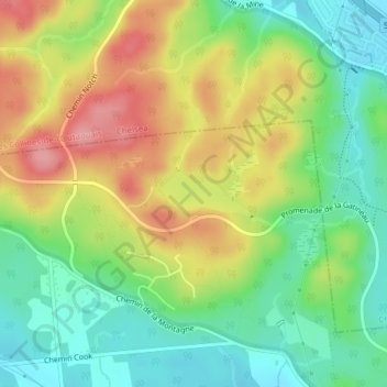
Name: Pink Lake topographic map, elevation, terrain.
Location: Pink Lake, Aylmer, Gatineau, Outaouais, Quebec, Canada (45.46678 -75.81115 45.47000 -75.80219)
Average elevation: 153 m
Minimum elevation: 105 m
Maximum elevation: 216 m
Thank you for supporting this site ❤️
Make a donation
Make a donation
Other topographic maps
Click on a map to view its topography, its elevation and its terrain.