
Stanley Lake topographic map
Interactive map
Click on the map to display elevation.
About this map
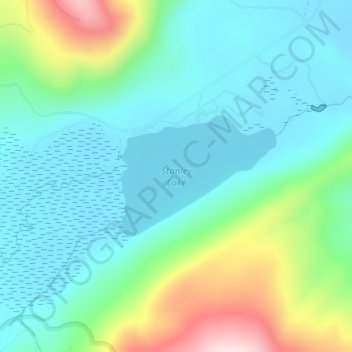
Name: Stanley Lake topographic map, elevation, terrain.
Location: Stanley Lake, Custer County, Idaho, United States (44.23892 -115.06491 44.24828 -115.04815)
Average elevation: 2,075 m
Minimum elevation: 1,979 m
Maximum elevation: 2,358 m
The lake is approximately seven miles (11 km) west of Stanley, readily accessed via a three-mile (5 km) spur road from State Highway 21. The surface elevation of the lake is 6,513 feet (1,985 m) above sea level.
Other topographic maps
Click on a map to view its topography, its elevation and its terrain.
Stanley
United States > Idaho > Custer County
Stanley, Custer County, Idaho, United States
Average elevation: 1,931 m
Pine Summit
United States > Idaho > Custer County
Pine Summit, Custer County, Idaho, United States
Average elevation: 2,315 m
Thousand Springs
United States > Idaho > Custer County
Thousand Springs, Custer County, Idaho, United States
Average elevation: 1,922 m
Challis
United States > Idaho > Custer County
Challis, Custer County, Idaho, United States
Average elevation: 1,626 m
Borah Peak
United States > Idaho > Custer County
Borah Peak, Custer County, Idaho, United States
Average elevation: 3,280 m
Lost River
United States > Idaho > Custer County
Lost River, Custer County, Idaho, United States
Average elevation: 2,198 m
Redfish Lake
United States > Idaho > Custer County
Redfish Lake, Custer County, Idaho, United States
Average elevation: 2,144 m