
Lost River topographic map
Interactive map
Click on the map to display elevation.
About this map
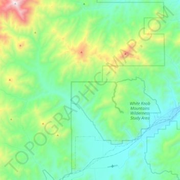
Name: Lost River topographic map, elevation, terrain.
Location: Lost River, Custer County, Idaho, United States (43.66949 -113.65445 43.82447 -113.42586)
Average elevation: 2,198 m
Minimum elevation: 1,798 m
Maximum elevation: 3,415 m
Other topographic maps
Click on a map to view its topography, its elevation and its terrain.
Stanley Lake
United States > Idaho > Custer County
Stanley Lake, Custer County, Idaho, United States
Average elevation: 2,075 m
Stanley
United States > Idaho > Custer County
Stanley, Custer County, Idaho, United States
Average elevation: 1,931 m
Pine Summit
United States > Idaho > Custer County
Pine Summit, Custer County, Idaho, United States
Average elevation: 2,315 m
Thousand Springs
United States > Idaho > Custer County
Thousand Springs, Custer County, Idaho, United States
Average elevation: 1,922 m
Challis
United States > Idaho > Custer County
Challis, Custer County, Idaho, United States
Average elevation: 1,626 m
Borah Peak
United States > Idaho > Custer County
Borah Peak, Custer County, Idaho, United States
Average elevation: 3,280 m
Redfish Lake
United States > Idaho > Custer County
Redfish Lake, Custer County, Idaho, United States
Average elevation: 2,144 m