
Make a donation
Huemul Island topographic map
Click on the map to display elevation.
Make a donation
About this map
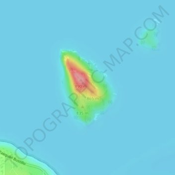
Name: Huemul Island topographic map, elevation, terrain.
Average elevation: 774 m
Minimum elevation: 767 m
Maximum elevation: 882 m
Make a donation
Other topographic maps
Click on a map to view its topography, its elevation and its terrain.
Make a donation
Make a donation
Make a donation
San Carlos de Bariloche
Argentina > Río Negro Province
Bariloche lies in the transition between a cool Mediterranean climate (Köppen Csb) and an Oceanic climate (Köppen: Cfb), with marked alpine characteristics (low nighttime temperatures, wide temperature variations, high thermal amplitude). The combination of its altitude, latitude, and predominance of…
Average elevation: 1,042 m
Make a donation
Make a donation
Municipio de Cipolletti
Argentina > Río Negro Province > Municipio de Cipolletti
Average elevation: 464 m
Make a donation