
اسد آباد ولسوالۍ topographic map
Interactive map
Click on the map to display elevation.
About this map
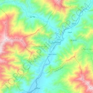
Name: اسد آباد ولسوالۍ topographic map, elevation, terrain.
Location: اسد آباد ولسوالۍ, Kounar, 2801, Afghanistan (34.78098 71.06373 34.94862 71.20583)
Average elevation: 1,355 m
Minimum elevation: 778 m
Maximum elevation: 2,617 m
Other topographic maps
Click on a map to view its topography, its elevation and its terrain.
دانگام ولسوالۍ
Afghanistan > Kounar > دانگام ولسوالۍ
دانگام ولسوالۍ, Kounar, Afghanistan
Average elevation: 1,972 m