
Thank you for supporting this site ❤️
Make a donation
Make a donation
Tjörns kommun topographic map
Click on the map to display elevation.
Thank you for supporting this site ❤️
Make a donation
Make a donation
About this map
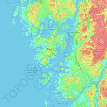
Name: Tjörns kommun topographic map, elevation, terrain.
Location: Tjörns kommun, Västra Götaland County, Sweden (57.86258 10.95912 58.10583 11.79519)
Average elevation: 29 m
Minimum elevation: -3 m
Maximum elevation: 186 m
Thank you for supporting this site ❤️
Make a donation
Make a donation
Other topographic maps
Click on a map to view its topography, its elevation and its terrain.
Thank you for supporting this site ❤️
Make a donation
Make a donation
Thank you for supporting this site ❤️
Make a donation
Make a donation