
Skamania County topographic map
Interactive map
Click on the map to display elevation.
About this map
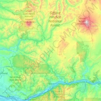
Name: Skamania County topographic map, elevation, terrain.
Location: Skamania County, Washington, United States (45.54858 -122.25001 46.38888 -121.51440)
Average elevation: 771 m
Minimum elevation: 0 m
Maximum elevation: 3,690 m
Other topographic maps
Click on a map to view its topography, its elevation and its terrain.
Artic
United States > Washington > Grays Harbor County
Artic, Grays Harbor County, Washington, United States
Average elevation: 75 m
Lake Wallula
United States > Washington > Benton County > Richland
Lake Wallula, Richland, Benton County, Washington, 99363, United States
Average elevation: 268 m
Pacific County
Pacific County, Washington, United States
Average elevation: 124 m