
Werdohl topographic map
Interactive map
Click on the map to display elevation.
About this map
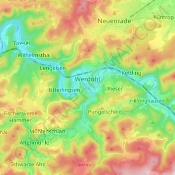
Name: Werdohl topographic map, elevation, terrain.
Location: Werdohl, Märkischer Kreis, Noordrijn-Westfalen, 58791, Duitsland (51.21886 7.69165 51.28871 7.81374)
Average elevation: 332 m
Minimum elevation: 161 m
Maximum elevation: 568 m
Other topographic maps
Click on a map to view its topography, its elevation and its terrain.
Iserlohn
Duitsland > Noordrijn-Westfalen > Märkischer Kreis
Iserlohn, Märkischer Kreis, Noordrijn-Westfalen, Duitsland
Average elevation: 251 m
Altena
Duitsland > Noordrijn-Westfalen > Märkischer Kreis
Altena, Märkischer Kreis, Noordrijn-Westfalen, 58762, Duitsland
Average elevation: 347 m
Neuenrade
Duitsland > Noordrijn-Westfalen > Märkischer Kreis
Neuenrade, Märkischer Kreis, Noordrijn-Westfalen, 58809, Duitsland
Average elevation: 350 m
Lüdenscheid
Duitsland > Noordrijn-Westfalen > Märkischer Kreis > Lüdenscheid
Lüdenscheid, Märkischer Kreis, Noordrijn-Westfalen, Duitsland
Average elevation: 384 m