
Logan County topographic map
Interactive map
Click on the map to display elevation.
About this map
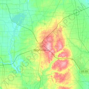
Name: Logan County topographic map, elevation, terrain.
Location: Logan County, Ohio, United States (40.22936 -84.01476 40.53875 -83.52002)
Average elevation: 340 m
Minimum elevation: 296 m
Maximum elevation: 470 m
Other topographic maps
Click on a map to view its topography, its elevation and its terrain.
Blue Rock
United States > Ohio > Muskingum County
Blue Rock, Muskingum County, Ohio, 43720, United States
Average elevation: 253 m
Findlay
United States > Ohio > Findlay
Findlay, Hancock County, Ohio, United States
Average elevation: 243 m