
Make a donation
Hualien County topographic map
Click on the map to display elevation.
Make a donation
About this map
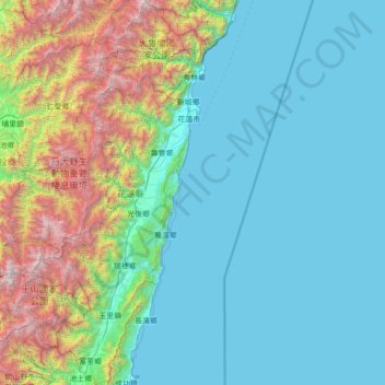
Name: Hualien County topographic map, elevation, terrain.
Location: Hualien County, Taiwan (23.09778 120.98660 24.37053 121.77382)
Average elevation: 686 m
Minimum elevation: 0 m
Maximum elevation: 3,857 m
Make a donation
Other topographic maps
Click on a map to view its topography, its elevation and its terrain.
Make a donation
Make a donation
Make a donation
Make a donation
Make a donation
Wuling
Taiwan > Nantou County > Renai Township
Wuling (Chinese: 武嶺; pinyin: Wǔlǐng, el 3275 m), formerly known as Sakuma Pass (佐久間峠, Sakuma-tōge), is a mountain pass located in Ren'ai, Nantou, Taiwan, transversing the Central Mountain Range near the peak of Hehuanshan within Taroko National Park. It is the highest paved road in elevation in Taiwan.
Average elevation: 3,079 m
Make a donation
Make a donation
Make a donation
Make a donation
Jiaming Lake
Taiwan > Taitung County > Haiduan
This oval-shaped lake is located along the Southern Cross-Island Highway. The lake surface is 120 meters long and 80 meters wide at an elevation of 3,310 meters. It is surrounded by emerald green forest plantation and wildlife. The area surrounds the lake has lodges and hiking trail with a length of 13 km.
Average elevation: 3,191 m
Make a donation
Make a donation
Make a donation
Make a donation
Qingjing Farm
Taiwan > Nantou County > Renai Township
The Qingjing Farm (traditional Chinese: 清境農場; simplified Chinese: 清境农场; pinyin: Qīngjìng Nóngchǎng), also known as Cingjing Farm, is a tourist attraction farm in Ren'ai Township, Nantou County, Taiwan. Located at an altitude of 1,700 ~2,000 meters, it's known as one of the three major high…
Average elevation: 1,540 m