
Make a donation
Ivars topographic map
Click on the map to display elevation.
Make a donation
About this map
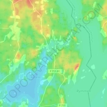
Name: Ivars topographic map, elevation, terrain.
Location: Ivars, Värnamo kommun, Sweden (57.06903 14.31322 57.10903 14.35322)
Average elevation: 180 m
Minimum elevation: 167 m
Maximum elevation: 204 m
Make a donation
Other topographic maps
Click on a map to view its topography, its elevation and its terrain.
Make a donation
Make a donation
Make a donation
Abisko National Park
Permafrost is common in the national park, though permafrost at lower elevations is disappearing because of global warming and increased snowfall.
Average elevation: 740 m
Make a donation
Make a donation
Make a donation
Sarek
Sarek National Park is the most mountainous region in Sweden and it is the part of the country that mostly resembles an alpine countryside. Within the park are 19 summits higher than 1,900 m (6,200 ft), the most noted being the second highest summit in Sweden after the Kebnekaise – the Sarektjåkkå with a…
Average elevation: 994 m
Make a donation
Make a donation
Make a donation
Make a donation
Make a donation
Make a donation
Make a donation
Make a donation
Make a donation
Make a donation
Make a donation
Make a donation
Make a donation
Make a donation
Make a donation
Make a donation
Make a donation
Sarek
Sarek National Park is the most mountainous region in Sweden and it is the part of the country that mostly resembles an alpine countryside. Within the park are 19 summits higher than 1,900 m (6,200 ft), the most noted being the second highest summit in Sweden after the Kebnekaise – the Sarektjåkkå with a…
Average elevation: 994 m
Make a donation
Ven
Along the entire coast, the island drops steeply towards the sea where the Öresund meets a rocky beach. This steep coast is called Backafall. Ven's backafall is a nature reserve established in 1990. There are no large forests, but smaller stands of trees occur closest to the coast the slightly higher…
Average elevation: 13 m
Make a donation