
Singaraja topographic map
Interactive map
Click on the map to display elevation.
About this map
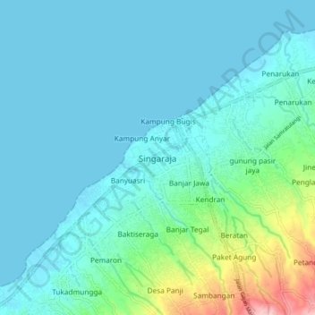
Name: Singaraja topographic map, elevation, terrain.
Location: Singaraja, Buleleng, Bali, 81116, Indonesië (-8.15336 115.04393 -8.07336 115.12393)
Average elevation: 31 m
Minimum elevation: 0 m
Maximum elevation: 200 m
Other topographic maps
Click on a map to view its topography, its elevation and its terrain.
Danau Buyan
Indonesië > Bali > Buleleng > Wana Giri
Danau Buyan, Wana Giri, Buleleng, Bali, Indonesië
Average elevation: 1,285 m