
Gitgit topographic map
Interactive map
Click on the map to display elevation.
About this map
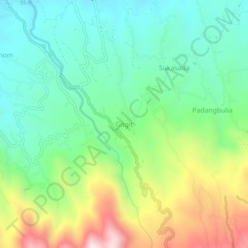
Name: Gitgit topographic map, elevation, terrain.
Location: Gitgit, Buleleng, Bali, Indonesië (-8.19801 115.11265 -8.15801 115.15265)
Average elevation: 427 m
Minimum elevation: 211 m
Maximum elevation: 864 m
Other topographic maps
Click on a map to view its topography, its elevation and its terrain.
Danau Buyan
Indonesië > Bali > Buleleng > Wana Giri
Danau Buyan, Wana Giri, Buleleng, Bali, Indonesië
Average elevation: 1,285 m