
Bray topographic map
Interactive map
Click on the map to display elevation.
About this map
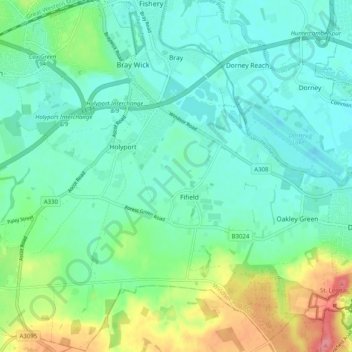
Name: Bray topographic map, elevation, terrain.
Location: Bray, Windsor and Maidenhead, Inglaterra, Reino Unido (51.45614 -0.75277 51.51809 -0.65257)
Average elevation: 36 m
Minimum elevation: 16 m
Maximum elevation: 92 m
Other topographic maps
Click on a map to view its topography, its elevation and its terrain.
Cookham
Reino Unido > Inglaterra > Windsor and Maidenhead
Cookham, Windsor and Maidenhead, Inglaterra, Reino Unido
Average elevation: 47 m
Windsor
Reino Unido > Inglaterra > Windsor and Maidenhead
Windsor, Windsor and Maidenhead, Inglaterra, Reino Unido
Average elevation: 32 m
Clewer Village
Reino Unido > Inglaterra > Windsor and Maidenhead
Clewer Village, Windsor and Maidenhead, Inglaterra, SL4 5JG, Reino Unido
Average elevation: 26 m