
Thank you for supporting this site ❤️
Make a donation
Make a donation
Rye topographic map
Click on the map to display elevation.
Thank you for supporting this site ❤️
Make a donation
Make a donation
About this map
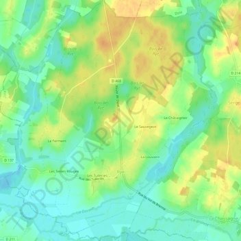
Name: Rye topographic map, elevation, terrain.
Average elevation: 203 m
Minimum elevation: 188 m
Maximum elevation: 221 m
Thank you for supporting this site ❤️
Make a donation
Make a donation
Other topographic maps
Click on a map to view its topography, its elevation and its terrain.
Jardins de l'Hôtel du Département
France > Bourgogne – Franche-Comté > Jura > Lons-le-Saunier
Average elevation: 299 m
Thank you for supporting this site ❤️
Make a donation
Make a donation
Abbaye en Grandvaux
France > Bourgogne – Franche-Comté > Jura > Grande-Rivière-Château
Average elevation: 956 m
Thank you for supporting this site ❤️
Make a donation
Make a donation