
Perg topographic map
Interactive map
Click on the map to display elevation.
About this map
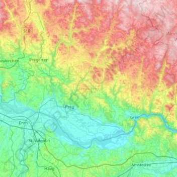
Name: Perg topographic map, elevation, terrain.
Location: Perg, Haute-Autriche, Autriche (48.15708 14.39849 48.42402 14.99217)
Average elevation: 477 m
Minimum elevation: 222 m
Maximum elevation: 998 m
Other topographic maps
Click on a map to view its topography, its elevation and its terrain.
Engelhartszell an der Donau
Autriche > Haute-Autriche > Bezirk Schärding
Engelhartszell an der Donau, Bezirk Schärding, Haute-Autriche, 4090, Autriche
Average elevation: 588 m
Ebensee am Traunsee
Autriche > Haute-Autriche > Bezirk Gmunden
Ebensee am Traunsee, Bezirk Gmunden, Haute-Autriche, 4802, Autriche
Average elevation: 1,009 m
Obertraun
Autriche > Haute-Autriche > Bezirk Gmunden
Obertraun, Bezirk Gmunden, Haute-Autriche, 4831, Autriche
Average elevation: 1,629 m
Gosau
Autriche > Haute-Autriche > Bezirk Gmunden
Gosau, Bezirk Gmunden, Haute-Autriche, 4824, Autriche
Average elevation: 1,336 m
Tiefgraben
Autriche > Haute-Autriche > Bezirk Vöcklabruck
Tiefgraben, Bezirk Vöcklabruck, Haute-Autriche, 5310, Autriche
Average elevation: 693 m
Schwarzensee
Autriche > Haute-Autriche > Bezirk Gmunden > St. Wolfgang im Salzkammergut
Schwarzensee, Bacherlalm, St. Wolfgang im Salzkammergut, Bezirk Gmunden, Haute-Autriche, 5360, Autriche
Average elevation: 837 m
Primesberg
Autriche > Haute-Autriche > Bezirk Gmunden > Bad Goisern am Hallstättersee > Bad Goisern > Primesberg
Primesberg, Bad Goisern, Bad Goisern am Hallstättersee, Bezirk Gmunden, Haute-Autriche, 4822, Autriche
Average elevation: 679 m
Braunau am Inn
Autriche > Haute-Autriche > Bezirk Braunau am Inn > Braunau am Inn > Braunau am Inn
Braunau am Inn, Bezirk Braunau am Inn, Haute-Autriche, 5280, Autriche
Average elevation: 375 m
Kirchdorf an der Krems
Autriche > Haute-Autriche > Bezirk Kirchdorf
Kirchdorf an der Krems, Bezirk Kirchdorf, Haute-Autriche, 4560, Autriche
Average elevation: 475 m
Gmunden
Autriche > Haute-Autriche > Bezirk Gmunden
Gmunden, Bezirk Gmunden, Haute-Autriche, 4810, Autriche
Average elevation: 692 m
Sankt Thomas
Autriche > Haute-Autriche > Sankt Thomas
Sankt Thomas, Bezirk Grieskirchen, Haute-Autriche, 4732, Autriche
Average elevation: 399 m
Pasching
Autriche > Haute-Autriche > Pasching
Pasching, Bezirk Linz-Land, Haute-Autriche, 4061, Autriche
Average elevation: 299 m
Kallham
Autriche > Haute-Autriche > Kallham
Kallham, Grieskirchen, Haute-Autriche, 4720, Autriche
Average elevation: 411 m
Roßleithen
Autriche > Haute-Autriche > Roßleithen
Roßleithen, Kirchdorf an der Krems, Haute-Autriche, 4575, Autriche
Average elevation: 978 m
Viermaiern
Autriche > Haute-Autriche > Viermaiern
Viermaiern, Braunau am Inn, Haute-Autriche, 5134, Autriche
Average elevation: 442 m
Schneeberg
Autriche > Haute-Autriche > Reichraming
Schneeberg, Reichraming, Steyr-Land, Haute-Autriche, 4462, Autriche
Average elevation: 905 m
Hinzenbach
Autriche > Haute-Autriche > Bezirk Eferding
Hinzenbach, Bezirk Eferding, Haute-Autriche, 4070, Autriche
Average elevation: 291 m
Windischgarsten
Autriche > Haute-Autriche > Windischgarsten
Windischgarsten, Kirchdorf an der Krems, Haute-Autriche, 4580, Autriche
Average elevation: 660 m
Perg
Autriche > Haute-Autriche > Bezirk Perg
Perg, Bezirk Perg, Haute-Autriche, 4320, Autriche
Average elevation: 290 m
Braunau am Inn
Autriche > Haute-Autriche > Bezirk Braunau am Inn
Braunau am Inn, Bezirk Braunau am Inn, Haute-Autriche, 5280, Autriche
Average elevation: 372 m
Burgstallkogel
Autriche > Haute-Autriche > Bad Goisern am Hallstättersee
Burgstallkogel, Bad Goisern am Hallstättersee, Gmunden, Haute-Autriche, 4822, Autriche
Average elevation: 736 m
Kirchdorf an der Krems
Kirchdorf an der Krems, Haute-Autriche, Autriche
Average elevation: 811 m
Traunsee
Autriche > Haute-Autriche > Traunkirchen
Traunsee, Aueck, Traunkirchen, Gmunden, Haute-Autriche, 4801, Autriche
Average elevation: 729 m
Höllerersee
Autriche > Haute-Autriche > Sankt Pantaleon
Höllerersee, Seeleitenstraße, Sankt Pantaleon, Braunau am Inn, Haute-Autriche, 5120, Autriche
Average elevation: 455 m
Großer Priel
Autriche > Haute-Autriche > Bezirk Kirchdorf > Hinterstoder
Großer Priel, Hinterstoder, Bezirk Kirchdorf, Haute-Autriche, 4573, Autriche
Average elevation: 1,919 m
Irrsee
Autriche > Haute-Autriche > Oberhofen am Irrsee
Irrsee, Fischhof, Oberhofen am Irrsee, Vöcklabruck, Haute-Autriche, 4894, Autriche
Average elevation: 659 m
Wölfling
Autriche > Haute-Autriche > Bezirk Rohrbach > Kirchberg ob der Donau
Wölfling, Kirchberg ob der Donau, Bezirk Rohrbach, Haute-Autriche, 4131, Autriche
Average elevation: 511 m
Almsee
Autriche > Haute-Autriche > Grünau im Almtal
Almsee, Almsee Ostuferweg, Grünau im Almtal, Gmunden, Haute-Autriche, 4645, Autriche
Average elevation: 732 m
Hallstättersee
Autriche > Haute-Autriche > Bad Goisern am Hallstättersee
Hallstättersee, Ostuferwanderweg, Bad Goisern am Hallstättersee, Gmunden, Haute-Autriche, 4822, Autriche
Average elevation: 912 m
Hoher Nock
Autriche > Haute-Autriche > Roßleithen
Hoher Nock, Roßleithen, Kirchdorf an der Krems, Haute-Autriche, 4575, Autriche
Average elevation: 1,545 m
Hoher Dachstein
Autriche > Haute-Autriche > Bezirk Gmunden > Hallstatt
Hoher Dachstein, Hallstatt, Bezirk Gmunden, Haute-Autriche, 4830, Autriche
Average elevation: 2,342 m
Hallstatt
Autriche > Haute-Autriche > Bezirk Gmunden
Hallstatt, Bezirk Gmunden, Haute-Autriche, 4830, Autriche
Average elevation: 1,515 m