
Province of Oxapampa topographic map
Interactive map
Click on the map to display elevation.
About this map
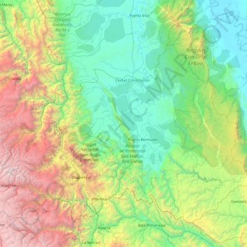
Name: Province of Oxapampa topographic map, elevation, terrain.
Location: Province of Oxapampa, Pasco, Peru (-10.91260 -75.98550 -9.44570 -74.13203)
Average elevation: 1,348 m
Minimum elevation: 152 m
Maximum elevation: 5,332 m
The Oxapampa Province (Spanish: Provincia de Oxapampa) is the largest of three provinces that make up the Pasco Region in Peru. The capital of the Oxapampa province is the city of Oxapampa. The province is located on the eastern slopes of the Andes reaching down to the lowlands of the Amazon Basin. The high point of the province is approximately 5,300 metres (17,400 ft) in elevation near the summit of Huaguruncho mountain in the Huancabamba District and the low point is approximately 200 metres (660 ft) on the Pachitea River in the Constitución District.
Other topographic maps
Click on a map to view its topography, its elevation and its terrain.
Huayllay National Sanctuary
Huayllay National Sanctuary, Huayllay, Province of Pasco, Pasco, Peru
Average elevation: 4,284 m
Huarautambo
Huarautambo, Yanahuanca, Province of Daniel Carrión, Pasco, Peru
Average elevation: 3,931 m
San Alberto
Peru > Pasco > Oxapampa > La Esperanza
San Alberto, La Esperanza, Oxapampa, Province of Oxapampa, Pasco, Peru
Average elevation: 1,926 m
Machicura
Peru > Pasco > Chontabamba > Machicura
Machicura, Chontabamba, Province of Oxapampa, Pasco, Peru
Average elevation: 1,878 m
Cerro de Pasco
Cerro de Pasco, Chaupimarca, Province of Pasco, Pasco, Peru
Average elevation: 4,239 m