
Thank you for supporting this site ❤️
Make a donation
Make a donation
Garden River topographic map
Click on the map to display elevation.
Thank you for supporting this site ❤️
Make a donation
Make a donation
About this map
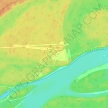
Name: Garden River topographic map, elevation, terrain.
Location: Garden River, Improvement District No. 24, Alberta, Canada (58.69084 -113.89328 58.73084 -113.85328)
Average elevation: 236 m
Minimum elevation: 219 m
Maximum elevation: 253 m
Thank you for supporting this site ❤️
Make a donation
Make a donation
Other topographic maps
Click on a map to view its topography, its elevation and its terrain.
Lake Claire
Canada > Alberta > Improvement District No. 24
The lake has a total area of 1,436 km2 (554 sq mi), with 21 km2 (8.1 sq mi) island area, and lies at an elevation of 213 m (699 ft). It is the largest lake located entirely within Albertan boundaries. Lake Athabasca, which straddles the border with Saskatchewan, is larger.
Average elevation: 214 m