
Make a donation
Yuanfang topographic map
Click on the map to display elevation.
Make a donation
About this map
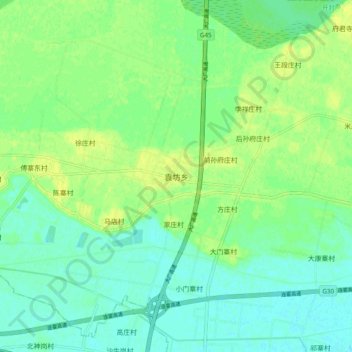
Name: Yuanfang topographic map, elevation, terrain.
Location: Yuanfang, Xiangfu District, Kaifeng, Henan, China (34.82533 114.46216 34.90533 114.54216)
Average elevation: 76 m
Minimum elevation: 68 m
Maximum elevation: 86 m
Make a donation
Other topographic maps
Click on a map to view its topography, its elevation and its terrain.
Make a donation
Make a donation
Make a donation
Make a donation
Make a donation
Guancheng Hui District
Guancheng Hui District has an elevation ranging from about 100 metres (330 ft) to 140 metres (460 ft) above sea level.
Average elevation: 112 m
Make a donation
Xichuan County
Xichuan is located south of Funiu Mountain. The county is about 107 kilometers from northwest to southeast, with a width of 46 kilometers and a total area of 2,798 square kilometers. Xichuan County is a horseshoe-shaped terrain that protrudes to the southeast in the northwest direction. The northwest is a low…
Average elevation: 319 m
Make a donation
Make a donation
Make a donation
Make a donation
Make a donation
Yongcheng City
Yongcheng is located in the Huai River Basin, in the easternmost part of Henan Province, with an average elevation of 33 meters. The Tuo hui River passes through the northern part of the western urban area and the southern part of the eastern urban area. The Mang Mountain is located in the northern Mangshan…
Average elevation: 37 m
Make a donation
Make a donation
Make a donation
Make a donation
Shangqiu
Shangqiu is the easternmost prefecture of Henan province. Its administrative area ranges in longitude from 114 °49′ E to 116° 39′ E and in latitude from 33° 43′ N to 34° 52′ N, covering 10,704 square kilometres (4,133 sq mi). The city lies on the North China Plain and is mostly flat, with…
Average elevation: 47 m
Make a donation
Make a donation