
Make a donation
Todi topographic map
Click on the map to display elevation.
Make a donation
About this map
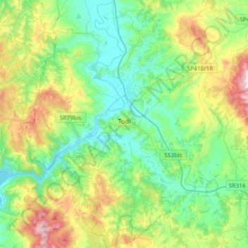
Name: Todi topographic map, elevation, terrain.
Location: Todi, Perugia, Umbria, 06059, Italy (42.67330 12.28999 42.88617 12.50908)
Average elevation: 343 m
Minimum elevation: 131 m
Maximum elevation: 881 m
Make a donation
Other topographic maps
Click on a map to view its topography, its elevation and its terrain.
Make a donation
Make a donation
Vaiano
Italy > Umbria > Perugia > Castiglione del Lago
Vaiano is a frazione of the comune of Castiglione del Lago in the Province of Perugia, Umbria, central Italy. It stands at an elevation of 371 metres above sea level. At the time of the Istat census of 2001 it had 234 inhabitants.
Average elevation: 306 m
Make a donation
Pettino
Italy > Umbria > Perugia > Campello sul Clitunno
It stands at an elevation of 1074 metres above sea level. At the time of the Istat census of 2001, it had only 74 inhabitants.
Average elevation: 1,141 m
San Leo Bastia
Italy > Umbria > Perugia > Città di Castello
San Leo Bastia is a frazione of the comune of Città di Castello in the Province of Perugia, Umbria, central Italy. It stands at an elevation of 320 metres above sea level. At the time of the Istat census of 2001 it had 213 inhabitants.
Average elevation: 404 m
Make a donation
Make a donation
Ponticelli
Ponticelli is a frazione of the comune of Città della Pieve in the Province of Perugia, Umbria, central Italy. It stands at an elevation of 249 metres above sea level. At the time of the Istat census of 2001 it had 610 inhabitants.
Average elevation: 275 m
Make a donation
Make a donation
Make a donation