
Make a donation
Grutti topographic map
Click on the map to display elevation.
Make a donation
About this map
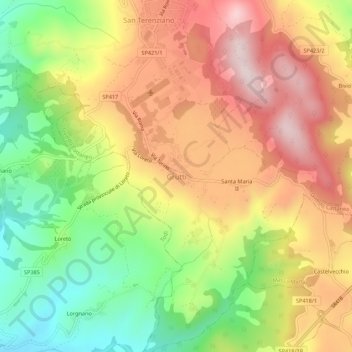
Name: Grutti topographic map, elevation, terrain.
Location: Grutti, Gualdo Cattaneo, Perugia, Umbria, 06035, Italy (42.82760 12.45702 42.86760 12.49702)
Average elevation: 420 m
Minimum elevation: 198 m
Maximum elevation: 633 m
Make a donation
Other topographic maps
Click on a map to view its topography, its elevation and its terrain.
Make a donation
Perugia
Though Perugia is located in the central part of Italy, the city experiences a humid subtropical climate (Köppen climate classification Cfa) similar to much of Northern Italy due to its inland location and the diverse, hilly topography of Umbria. Typically, summers are warm to hot and humid, while winters are…
Average elevation: 338 m
Make a donation
Make a donation
Bastia Umbra
Bastia is situated in the Umbrian Valley [it] at a modest elevation. It stands in an open plain, with the horizon only limited to the east by Monte Subasio at a distance of 4 miles (6.4 km).
Average elevation: 203 m
Make a donation
Make a donation
Trevi
The natural environment of the territory as a whole remains largely unspoiled, this despite being significantly populated for millennia. The mountainous area is now witnessing a considerable depopulation — as elsewhere in Italy, in the second half of the 20th century settlements at the highest elevations…
Average elevation: 507 m
Perugia
Though Perugia is located in the central part of Italy, the city experiences a humid subtropical climate (Köppen climate classification Cfa) similar to much of Northern Italy due to its inland location and the diverse, hilly topography of Umbria. Typically, summers are warm to hot and humid, while winters are…
Average elevation: 338 m
Make a donation
Make a donation
Nocera Umbra
Nocera Umbra is a town and comune in the province of Perugia, Italy, 15 kilometers north of Foligno, at an altitude of 520 m above sea-level. The comune, covering an area of 157.19 km2, is one of the largest in Umbria. It is one of I Borghi più belli d'Italia ("The most beautiful villages of Italy").
Average elevation: 695 m
Make a donation
Trevi
The natural environment of the territory as a whole remains largely unspoiled, this despite being significantly populated for millennia. The mountainous area is now witnessing a considerable depopulation — as elsewhere in Italy, in the second half of the 20th century settlements at the highest elevations…
Average elevation: 507 m