
Make a donation
Trevi topographic map
Click on the map to display elevation.
Make a donation
Trevi
The natural environment of the territory as a whole remains largely unspoiled, this despite being significantly populated for millennia. The mountainous area is now witnessing a considerable depopulation — as elsewhere in Italy, in the second half of the 20th century settlements at the highest elevations have been rapidly losing their inhabitants to the plains. The most important growth areas since the period following World War II have been Borgo Trevi (commercial, residential, and offices), Pietrarossa (industrial), and Matigge (light and medium industry, commercial).
Make a donation
About this map
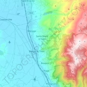
Name: Trevi topographic map, elevation, terrain.
Location: Trevi, Perugia, Umbria, 06039, Italy (42.83403 12.69013 42.93376 12.82816)
Average elevation: 507 m
Minimum elevation: 200 m
Maximum elevation: 1,418 m
Make a donation
Other topographic maps
Click on a map to view its topography, its elevation and its terrain.
Vaiano
Italy > Umbria > Perugia > Castiglione del Lago
Vaiano is a frazione of the comune of Castiglione del Lago in the Province of Perugia, Umbria, central Italy. It stands at an elevation of 371 metres above sea level. At the time of the Istat census of 2001 it had 234 inhabitants.
Average elevation: 306 m
Make a donation
Make a donation
Casalalta
Italy > Umbria > Perugia > Collazzone
Casalalta is a frazione of the comune of Collazzone in the Province of Perugia, Umbria, central Italy. It stands at an elevation of 325 metres above sea level. At the time of the Istat census of 2001 it had 60 inhabitants.
Average elevation: 273 m
Make a donation
Make a donation
Ponticelli
Ponticelli is a frazione of the comune of Città della Pieve in the Province of Perugia, Umbria, central Italy. It stands at an elevation of 249 metres above sea level. At the time of the Istat census of 2001 it had 610 inhabitants.
Average elevation: 275 m
Make a donation
San Leo Bastia
Italy > Umbria > Perugia > Città di Castello
San Leo Bastia is a frazione of the comune of Città di Castello in the Province of Perugia, Umbria, central Italy. It stands at an elevation of 320 metres above sea level. At the time of the Istat census of 2001 it had 213 inhabitants.
Average elevation: 404 m
Make a donation
Pettino
Italy > Umbria > Perugia > Campello sul Clitunno
It stands at an elevation of 1074 metres above sea level. At the time of the Istat census of 2001, it had only 74 inhabitants.
Average elevation: 1,141 m
Make a donation
Make a donation
Make a donation