
Troistorrents topographic map
Interactive map
Click on the map to display elevation.
About this map
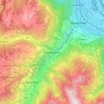
Name: Troistorrents topographic map, elevation, terrain.
Location: Troistorrents, Monthey, Valais, Suisse (46.19876 6.82059 46.25929 6.94397)
Average elevation: 1,231 m
Minimum elevation: 389 m
Maximum elevation: 2,281 m
Troistorrents est une commune suisse du canton du Valais, située dans le district de Monthey. Elle occupe une partie du val d'Illiez et la plus grande partie du val de Morgins. Troistorrents, village chef-lieu, est situé à 765 m d'altitude. On peut s'y rendre par route ou en prenant le train de l'AOMC en gare de Monthey.
Other topographic maps
Click on a map to view its topography, its elevation and its terrain.
Saint-Gingolph
Saint-Gingolph, Monthey, Valais, 1898, Suisse
Average elevation: 1,104 m
Val-d'Illiez
Val-d'Illiez, Monthey, Valais, 1873, Suisse
Average elevation: 1,672 m
Port-Valais
Suisse > Valais > Monthey > Port-Valais
Port-Valais, Monthey, Valais, 1897, Suisse
Average elevation: 655 m
Collombey-Muraz
Collombey-Muraz, Monthey, Valais, 1893, Suisse
Average elevation: 562 m
Les Crosets
Suisse > Valais > Monthey > Val-d'Illiez
Les Crosets, Val-d'Illiez, Monthey, Valais, 1873, Suisse
Average elevation: 1,773 m
Champoussin
Champoussin, Val-d'Illiez, Monthey, Valais, 1873, Suisse
Average elevation: 1,572 m