
Champéry topographic map
Interactive map
Click on the map to display elevation.
About this map
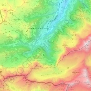
Name: Champéry topographic map, elevation, terrain.
Location: Champéry, Monthey, Valais, 1874, Suisse (46.12927 6.79029 46.19007 6.91014)
Average elevation: 1,883 m
Minimum elevation: 820 m
Maximum elevation: 3,251 m
Champéry est une commune suisse du canton du Valais, située dans le district de Monthey. À une altitude moyenne de 1 050 mètres, elle se situe dans le Val d'Illiez, au pied du massif des dents du Midi.
Other topographic maps
Click on a map to view its topography, its elevation and its terrain.
Saint-Gingolph
Saint-Gingolph, Monthey, Valais, 1898, Suisse
Average elevation: 1,104 m
Val-d'Illiez
Val-d'Illiez, Monthey, Valais, 1873, Suisse
Average elevation: 1,672 m
Troistorrents
Troistorrents, Monthey, Valais, Suisse
Average elevation: 1,231 m
Port-Valais
Suisse > Valais > Monthey > Port-Valais
Port-Valais, Monthey, Valais, 1897, Suisse
Average elevation: 655 m
Collombey-Muraz
Collombey-Muraz, Monthey, Valais, 1893, Suisse
Average elevation: 562 m
Les Crosets
Suisse > Valais > Monthey > Val-d'Illiez
Les Crosets, Val-d'Illiez, Monthey, Valais, 1873, Suisse
Average elevation: 1,773 m
Champoussin
Champoussin, Val-d'Illiez, Monthey, Valais, 1873, Suisse
Average elevation: 1,572 m