
Thank you for supporting this site ❤️
Make a donation
Make a donation
Bulverde topographic map
Click on the map to display elevation.
Thank you for supporting this site ❤️
Make a donation
Make a donation
About this map
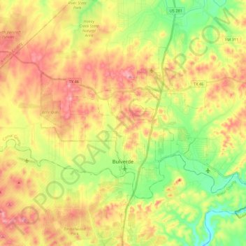
Name: Bulverde topographic map, elevation, terrain.
Location: Bulverde, Comal County, Texas, United States (29.71563 -98.52530 29.83061 -98.31001)
Average elevation: 364 m
Minimum elevation: 267 m
Maximum elevation: 468 m
Thank you for supporting this site ❤️
Make a donation
Make a donation
Other topographic maps
Click on a map to view its topography, its elevation and its terrain.
Thank you for supporting this site ❤️
Make a donation
Make a donation
Thank you for supporting this site ❤️
Make a donation
Make a donation
Thank you for supporting this site ❤️
Make a donation
Make a donation