
Thank you for supporting this site ❤️
Make a donation
Make a donation
Bele topographic map
Click on the map to display elevation.
Thank you for supporting this site ❤️
Make a donation
Make a donation
About this map
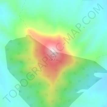
Name: Bele topographic map, elevation, terrain.
Average elevation: 1,132 m
Minimum elevation: 990 m
Maximum elevation: 1,461 m
Thank you for supporting this site ❤️
Make a donation
Make a donation
Other topographic maps
Click on a map to view its topography, its elevation and its terrain.
Tina River
South Africa > Eastern Cape > O.R. Tambo District Municipality > Mhlontlo Local Municipality
Average elevation: 557 m
Tina River
South Africa > Eastern Cape > O.R. Tambo District Municipality > Mhlontlo Local Municipality
Average elevation: 777 m