
Thank you for supporting this site ❤️
Make a donation
Make a donation
Fort Fraser topographic map
Click on the map to display elevation.
Thank you for supporting this site ❤️
Make a donation
Make a donation
About this map
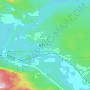
Name: Fort Fraser topographic map, elevation, terrain.
Average elevation: 732 m
Minimum elevation: 657 m
Maximum elevation: 1,143 m
Thank you for supporting this site ❤️
Make a donation
Make a donation
Other topographic maps
Click on a map to view its topography, its elevation and its terrain.
Dorman Lake
Canada > British Columbia > Regional District of Bulkley-Nechako > Area D (Endako/Fort Fraser)
Average elevation: 792 m
Emmett Lake
Canada > British Columbia > Regional District of Bulkley-Nechako > Area D (Endako/Fort Fraser)
Average elevation: 966 m