
Tihange topographic map
Interactive map
Click on the map to display elevation.
About this map
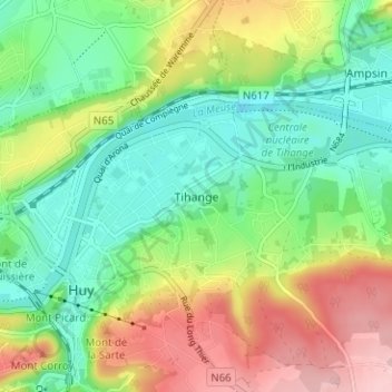
Name: Tihange topographic map, elevation, terrain.
Location: Tihange, Huy, Liège, Wallonie, 4500, Belgique (50.50759 5.23937 50.54759 5.27937)
Average elevation: 128 m
Minimum elevation: 55 m
Maximum elevation: 246 m
Other topographic maps
Click on a map to view its topography, its elevation and its terrain.