
Make a donation
Manjung topographic map
Click on the map to display elevation.
Make a donation
About this map
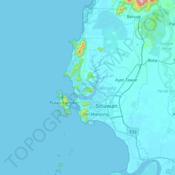
Name: Manjung topographic map, elevation, terrain.
Location: Manjung, Perak, Malaysia (3.99611 100.52832 4.55239 100.86001)
Average elevation: 11 m
Minimum elevation: -4 m
Maximum elevation: 722 m
Make a donation
Other topographic maps
Click on a map to view its topography, its elevation and its terrain.
Make a donation
Make a donation
Seri Iskandar
Seri Iskandar (Jawi: سري إسكندر, Chinese: 斯里依斯干达) is a major town within the Perak Tengah District in the state of Perak, Malaysia. It is situated about 40 kilometers southwest of the city of Ipoh, the state capital. The town is at an average elevation of 29 meters above the sea level. The…
Average elevation: 29 m
Make a donation
Make a donation
Make a donation
Make a donation
Make a donation
Make a donation
Make a donation
Make a donation
Make a donation
Make a donation
Make a donation
Make a donation
Make a donation
Make a donation
Make a donation
Ayer Tawar
Ayer Tawar is located on the eastern portion of Manjung District, about 60 kilometres west of the state capital Ipoh, and about 22 kilometres northeast of Lumut, where the largest Malaysian naval base is situated. Its average elevation is 13 metres above the sea level.
Average elevation: 13 m
Make a donation
Make a donation
Make a donation
Make a donation
Make a donation
Make a donation
Make a donation
Make a donation