
West Oxfordshire topographic map
Interactive map
Click on the map to display elevation.
About this map
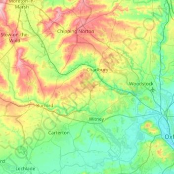
Name: West Oxfordshire topographic map, elevation, terrain.
Location: West Oxfordshire, Oxfordshire, Inglaterra, Reino Unido (51.68381 -1.71950 51.99685 -1.28615)
Average elevation: 119 m
Minimum elevation: 55 m
Maximum elevation: 273 m
Other topographic maps
Click on a map to view its topography, its elevation and its terrain.
Abingdon
Reino Unido > Inglaterra > Oxfordshire > Vale of White Horse
Abingdon, Vale of White Horse, Oxfordshire, Inglaterra, OX14 3UJ, Reino Unido
Average elevation: 64 m
Wallingford
Reino Unido > Inglaterra > Oxfordshire > South Oxfordshire
Wallingford, South Oxfordshire, Oxfordshire, Inglaterra, Reino Unido
Average elevation: 51 m
Bicester
Reino Unido > Inglaterra > Oxfordshire > Cherwell > Bicester
Bicester, Cherwell, Oxfordshire, South East England, Inglaterra, Reino Unido
Average elevation: 76 m
Oxford
Reino Unido > Inglaterra > Oxfordshire
Oxford, Oxfordshire, Inglaterra, Reino Unido
Average elevation: 81 m
Henley-on-Thames
Reino Unido > Inglaterra > Oxfordshire > South Oxfordshire
Henley-on-Thames, South Oxfordshire, Oxfordshire, Inglaterra, RG9 2AN, Reino Unido
Average elevation: 78 m