
Khôst topographic map
Interactive map
Click on the map to display elevation.
About this map
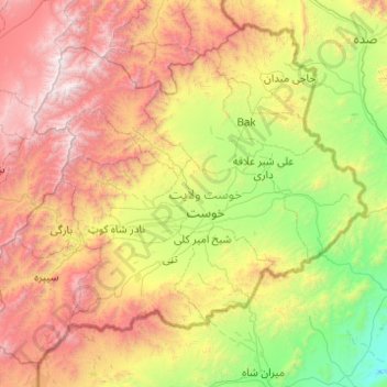
Name: Khôst topographic map, elevation, terrain.
Location: Khôst, Afghanistan (33.01939 69.34557 33.73867 70.32851)
Average elevation: 1,699 m
Minimum elevation: 551 m
Maximum elevation: 3,641 m
Other topographic maps
Click on a map to view its topography, its elevation and its terrain.
villege
Afghanistan > Khôst > نادرشاه کوټ ولسوالۍ > villege
villege, نادرشاه کوټ ولسوالۍ, Khôst, Afghanistan
Average elevation: 1,484 m