
Wiesenthau topographic map
Interactive map
Click on the map to display elevation.
About this map
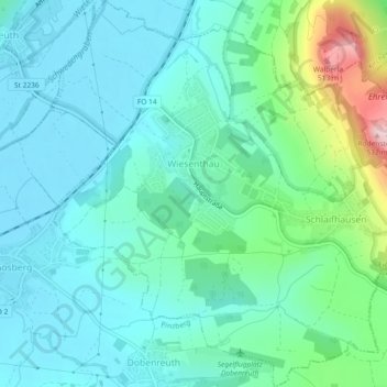
Name: Wiesenthau topographic map, elevation, terrain.
Average elevation: 323 m
Minimum elevation: 269 m
Maximum elevation: 528 m
Other topographic maps
Click on a map to view its topography, its elevation and its terrain.
Gaiganz
Deutschland > Bayern > Landkreis Forchheim
Das Kirchdorf befindet sich am Westrand der Fränkischen Schweiz, etwa drei Kilometer ostnordöstlich von Effeltrich. Es liegt auf einer Höhe von 332 m ü. NHN im Tal des Waillenbaches, eines Zulaufs der Wiesent.
Average elevation: 364 m