
Gaiganz topographic map
Interactive map
Click on the map to display elevation.
Gaiganz
Das Kirchdorf befindet sich am Westrand der Fränkischen Schweiz, etwa drei Kilometer ostnordöstlich von Effeltrich. Es liegt auf einer Höhe von 332 m ü. NHN im Tal des Waillenbaches, eines Zulaufs der Wiesent.
About this map
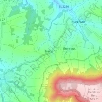
Name: Gaiganz topographic map, elevation, terrain.
Average elevation: 364 m
Minimum elevation: 284 m
Maximum elevation: 551 m
Other topographic maps
Click on a map to view its topography, its elevation and its terrain.
Forchheim
Deutschland > Bayern > Landkreis Forchheim
In dieser Zeit fanden in Forchheim zahlreiche Reichstage und Fürstentage statt. Der erste Aufenthalt eines ostfränkischen Königs ist für 849 belegt. Den Höhepunkt ihrer Bedeutung hatte die Pfalz im Jahre 900, als dort am 4. Februar der erst sechsjährige Ludwig das Kind zum König gewählt und gekrönt…
Average elevation: 299 m
Ebermannstadt
Deutschland > Bayern > Landkreis Forchheim
Die Stadt liegt im Freistaat Bayern, rund 35 km nördlich von Nürnberg und etwa 25 km südöstlich von Bamberg im Naturpark Fränkische Schweiz-Veldensteiner Forst im Tal der Wiesent auf einer Höhe von 292 bis 545 m ü. NHN. Durch ihre Lage nennt sich die Stadt selbst „das Herz der Fränkischen Schweiz“…
Average elevation: 420 m