
Thank you for supporting this site ❤️
Make a donation
Make a donation
Cofimvaba topographic map
Click on the map to display elevation.
Thank you for supporting this site ❤️
Make a donation
Make a donation
About this map
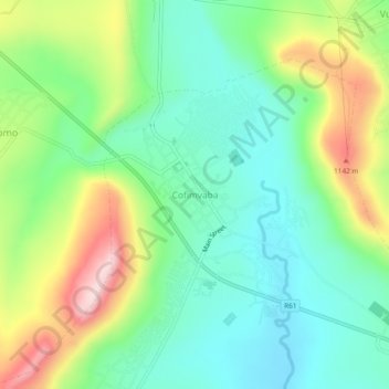
Name: Cofimvaba topographic map, elevation, terrain.
Average elevation: 997 m
Minimum elevation: 894 m
Maximum elevation: 1,199 m
Thank you for supporting this site ❤️
Make a donation
Make a donation
Other topographic maps
Click on a map to view its topography, its elevation and its terrain.
Qamata River
South Africa > Eastern Cape > Chris Hani District Municipality > Intsika Yethu Local Municipality
Average elevation: 894 m
Tsojana Dam
South Africa > Eastern Cape > Chris Hani District Municipality > Intsika Yethu Local Municipality > Mkwezweni
Average elevation: 1,131 m
Tsomo
South Africa > Eastern Cape > Chris Hani District Municipality > Intsika Yethu Local Municipality
Average elevation: 977 m