
Thank you for supporting this site ❤️
Make a donation
Make a donation
Stutterheim topographic map
Click on the map to display elevation.
Thank you for supporting this site ❤️
Make a donation
Make a donation
About this map
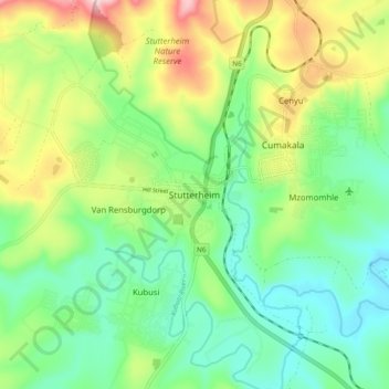
Name: Stutterheim topographic map, elevation, terrain.
Average elevation: 834 m
Minimum elevation: 727 m
Maximum elevation: 1,044 m
Thank you for supporting this site ❤️
Make a donation
Make a donation
Other topographic maps
Click on a map to view its topography, its elevation and its terrain.
Isidenge Main Forest
South Africa > Eastern Cape > Amathole District Municipality > Amahlathi Local Municipality > Zindenge
Average elevation: 1,061 m
Gxulu
South Africa > Eastern Cape > Amathole District Municipality > Amahlathi Local Municipality > Keiskammahoek
Average elevation: 809 m