
Make a donation
Peloponnese topographic map
Click on the map to display elevation.
Make a donation
About this map
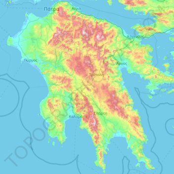
Name: Peloponnese topographic map, elevation, terrain.
Location: Peloponnese, Greece (36.38534 21.10507 38.34141 23.52452)
Average elevation: 257 m
Minimum elevation: -6 m
Maximum elevation: 2,293 m
Make a donation
Other topographic maps
Click on a map to view its topography, its elevation and its terrain.
Athens
Greece > Attica > Regional Unit of Central Athens
Owing to the rain shadow of the Pindus Mountains, annual precipitation of Athens is lower than most other parts of Greece, especially western Greece. As an example, Ioannina receives around 1,300 mm (51 in) per year, and Agrinio around 800 mm (31 in) per year. Daily average highs for July have been measured…
Average elevation: 168 m
Epitalio
Greece > Western Greece > Elis Regional Unit > Municipality of Pyrgos
Average elevation: 24 m
Make a donation
Archanes
Greece > Region of Crete > Heraklion Regional Unit > Archanes Municipal Unit
Average elevation: 333 m
Imera
Greece > Epirus and Western Macedonia > Kozani Regional Unit > Servia Municipal Unit
Average elevation: 418 m
Leontio
Greece > Peloponnese Region > Corinthia Regional Unit > Municipality of Nemea
Average elevation: 456 m
Make a donation
Ioannina
Greece > Epirus > Ioannina Regional Unit
Ioannina (Greek: Ιωάννινα Ioánnina [i.oˈa.ni.na] (listen)), often called Yannena (Γιάννενα Yánnena [ˈʝa.ne.na]) within Greece, is the capital and largest city of the Ioannina regional unit and of Epirus, an administrative region in north-western Greece. According to the 2011 census, the…
Average elevation: 724 m
Eleusis
Greece > Attica > Regional Unit of West Attica > Municipal Unit of Elefsina
Average elevation: 30 m
Make a donation
Taygeti
Greece > Peloponnese Region > Laconia Regional Unit > Municipal Unit of Mystras
Average elevation: 806 m
Λαγονήσι
Greece > Attica > Regional Unit of East Attica > Kalyvia Thorikou Municipal Unit
Average elevation: 30 m
Make a donation
Athens
Greece > Attica > Regional Unit of Central Athens
The southern section of the Athens metropolitan area (i.e., Elliniko, Athens Riviera) lies in the transitional zone between Mediterranean (Csa) and hot semi-arid climate (BSh), with its port-city of Piraeus being the most extreme example, receiving just 331.9 millimetres (13.07 in) per year. The areas to the…
Average elevation: 168 m
Krathio
Greece > Western Greece > Achaia Regional Unit > Municipal Unit of Akrata
Average elevation: 54 m
Neo Perivoli
Greece > Thessaly > Larisa Regional Unit > Municipal Unit of Kileler
Average elevation: 146 m
Make a donation
Alexandreia
Greece > Central Macedonia > Imathia Regional Unit
Alexandreia is a located in the vast plain north of the river Aliakmonas and west of the river Axios, named Kampania or also Roumlouki. Its economy is chiefly based on the agricultural utilization of the surrounding fields. The area around Alexandreia has the greatest production of peaches in Greece and…
Average elevation: 24 m
Meteora
Greece > Thessaly > Trikala Regional Unit > Kastraki
The Monastery of Rousanou is believed to have been constructed, like many of the other monasteries, in the 14th century. The cathedral is believed to have been built in the 16th century and later decorated in 1540. The name Rousanou is believed to come from the first group of monks who settled on the rock from…
Average elevation: 429 m
Make a donation
Hymettus
Greece > Attica > Regional Unit of Central Athens
The highest point of the mountain range is Evzonas (Εύζωνας) with an elevation of 1,026 m (3,366 ft). The 16 km (9.9 mi) length of Hymettus stretches from Athens to the Saronic Gulf. It is 6 to 7 km from east to west. In ancient times, the highest point was known as Megas Hymettos and the southern peaks…
Average elevation: 680 m
Dimitsana
Greece > Peloponnese Region > Arcadia Regional Unit > Municipal Unit of Dimitsana
Dimitsana is built on a mountain slope at an elevation of 950 meters. From its southern side a marvelous view of the Megalopolis plain and Taygetus is provided. Dimitsana is located 53 km east of Pyrgos, 31 km northwest of Tripoli, 23 km northwest of Megalopoli and 17 km northeast of Andritsaina. The village…
Average elevation: 1,025 m
Make a donation
Patras
Greece > Peloponnese, Western Greece and the Ionian > Achaia Regional Unit
A central feature of the urban geography of Patras is its division into upper and lower sections. This is the result of an interplay between natural geography and human settlement patterns; the lower section of the city (Kato Poli), which includes the 19th-century urban core and the port, is adjacent to the…
Average elevation: 283 m
Make a donation
Athens
Greece > Attica > Regional Unit of Central Athens
Owing to the rain shadow of the Pindus Mountains, annual precipitation of Athens is lower than most other parts of Greece, especially western Greece. As an example, Ioannina receives around 1,300 mm (51 in) per year, and Agrinio around 800 mm (31 in) per year. Daily average highs for July have been measured…
Average elevation: 168 m
Argos
Greece > Peloponnese, Western Greece and the Ionian > Argolis Regional Unit
Average elevation: 322 m
Nea Makri
Greece > Attica > Regional Unit of East Attica > Nea Makri Municipal Unit
Average elevation: 122 m
Make a donation
Astakos
Greece > Western Greece > Aetolia-Acarnania Regional Unit > Municipal Unit of Astakos
Average elevation: 225 m
Mount Ainos National Park
Greece > Ioanian Islands > Kefallonia Regional Unit > Municipal Unit of Elios-Proni
Average elevation: 501 m
Make a donation
Pine
Greece > Western Greece > Aetolia-Acarnania Regional Unit > Municipal Unit of Palairos
Average elevation: 65 m
Περτούλι
Greece > Thessaly > Trikala Regional Unit
Pertouli is a small mountain village within the province of Trikala in Greece and is situated at an altitude of 1,150 metres on the central part of the Pindos mountain range.
Average elevation: 1,358 m
Περτούλι
Greece > Thessaly > Trikala Regional Unit
Pertouli is a small mountain village within the province of Trikala in Greece and is situated at an altitude of 1,150 metres on the central part of the Pindos mountain range.
Average elevation: 1,358 m
Make a donation
Συκή
Greece > Thessaly > Regional Unit of Magnesia > Municipal Unit of Afetes
Average elevation: 220 m
Malia
Greece > Region of Crete > Heraklion Regional Unit > Malia Municipal Unit
Average elevation: 199 m
Make a donation
Labyrintaki Cave
Greece > Region of Crete > Heraklion Regional Unit > Mires Municipal Unit
Average elevation: 308 m
Make a donation
Σέρβια
Greece > Epirus and Western Macedonia > Kozani Regional Unit > Servia Municipal Unit
The Philharmonic band of the town, established in 1928, is run by the "Morphotikos Omilos Servion", which is the main Cultural Society of the town. It organises a wide range of cultural events and supports teaching classes for children and adults in painting, dance, choir, and chess. Hang gliding is prominent…
Average elevation: 565 m
Rapsani
Greece > Thessaly > Larisa Regional Unit > Municipal Unit of Kato Olympos
Rapsani is sited at an altitude of 600 meters. The location of Peneus river at the level of the station Rapsani is a scenic landscape. The town is close (5 km) from a station that bears the same name.
Average elevation: 501 m
Pylos
Greece > Peloponnese Region > Messenia Regional Unit
The erection of this fort led to one of the most memorable events in the Peloponnesian War. Thucydides has given a minute account of the topography of the district, which, though clear and consistent with itself, does not coincide, in all points, with the existing locality, Thucydides describes the harbour, of…
Average elevation: 79 m
Make a donation
Ζήρεια
Greece > Peloponnese Region > Corinthia Regional Unit > Municipal Unit of Xylokastro
Average elevation: 1,561 m
Στενά Νέστου
Greece > Macedonia and Thrace > Kavala Regional Unit > Paradisos
Average elevation: 449 m
Make a donation
Πρόδρομος
Greece > Thessaly and Central Greece > Regional Unit of Boeotia > Δημοτική Ενότητα Θίσβης
Average elevation: 368 m
Make a donation
Athens
Greece > Attica > Regional Unit of Central Athens
The southern section of the Athens metropolitan area (i.e., Elliniko, Athens Riviera) lies in the transitional zone between Mediterranean (Csa) and hot semi-arid climate (BSh), with its port-city of Piraeus being the most extreme example, receiving just 331.9 millimetres (13.07 in) per year. The areas to the…
Average elevation: 168 m
Magouliana
Greece > Peloponnese Region > Arcadia Regional Unit > Municipal Unit of Vytina
Average elevation: 1,176 m
Make a donation
Make a donation
Makrichori
Greece > Thessaly > Larisa Regional Unit > Municipal Unit of Makrichori
Average elevation: 139 m
Make a donation
Tsivili beach
Greece > Ioanian Islands > Zakynthos Regional Unit > Arkadii Municipal Unit
Average elevation: 15 m
Agios Konstantinos
Greece > Northern Aegean > Samos Regional Unit > Municipal Unit of Vathy
Average elevation: 135 m
Vourvourou
Greece > Central Macedonia > Chalkidiki Regional Unit > Sithonia Municipal Unit
Average elevation: 94 m
Make a donation
Kavala
Greece > Eastern Macedonia and Thrace > Kavala Regional Unit
On July 16, 2022, Meridian Flight 3032 crashed nearby. The Ukrainian-registered Antonov An-12BK was carrying 11.5 tons of ammunition from Niš to Dhaka when the plane began to lose altitude over the Aegean and turned around, but went down 35 kilometers west of Kavala Airport. All 8 crew members were killed.
Average elevation: 173 m
Vergina
Greece > Central Macedonia > Imathia Regional Unit > Veria Municipality
Average elevation: 141 m
Make a donation
Vikos–Aoos National Park
Greece > Epirus > Ioannina Regional Unit
The Vikos–Aoös National Park (Greek: Εθνικός Δρυμός Βίκου–Αώου, romanized: Ethnikós Drymós Víkou–Aóou) is a national park in the region of Epirus in northwestern Greece. The park, founded in 1973, is one of ten national parks in mainland Greece and is located 30 kilometres (19…
Average elevation: 1,147 m
Pinios
Greece > Western Greece > Elis Regional Unit > Municipal Unit of Lassion > Αντρώνι
Average elevation: 558 m
Sindos
Greece > Central Macedonia > Thessaloniki Regional Unit > Municipal Unit of Echedoros
Average elevation: 7 m
Make a donation
Kampos Marathokampou
Greece > Northern Aegean > Samos Regional Unit > Municipal Unit of Marathokabos
Average elevation: 99 m
Souli
Greece > Peloponnese Region > Arcadia Regional Unit > Municipal Unit of Megalopoli
Souli (Greek: Σούλι) is a village and a community in the municipality of Megalopoli in southwestern Arcadia, Greece. The community consists of the mountain villages Souli and Derveni. Both villages are located in the mountains on the border with Messenia, at about 500 m elevation. Derveni is on the old…
Average elevation: 569 m
Makrichori
Greece > Thessaly > Larisa Regional Unit > Municipal Unit of Makrichori
Average elevation: 139 m
Make a donation
Charakas
Greece > Region of Crete > Heraklion Regional Unit > Asterousia Municipal Unit
The community of Charakas (Δημοτική Κοινότητα Χάρακος) consists of the village Charakas and the smaller villages Agia Fotia (Αγιά Φωτιά) (pop. 22, at elevation 275 m, 2 km to the West from Charakas) and Doraki (Δωράκι) (pop. 24, at elevation 310 m, 1.5 km to the East from Charakas).
Average elevation: 357 m
Αβία
Greece > Peloponnese Region > Messenia Regional Unit > Municipal Unit of Avia
Average elevation: 45 m
Make a donation
Make a donation