
Thank you for supporting this site ❤️
Make a donation
Make a donation
Eastern Development Region topographic map
Click on the map to display elevation.
Thank you for supporting this site ❤️
Make a donation
Make a donation
About this map
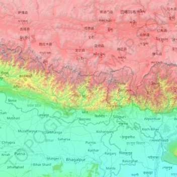
Name: Eastern Development Region topographic map, elevation, terrain.
Location: Eastern Development Region, Nepal (24.81597 84.80629 30.01597 90.00629)
Average elevation: 2,441 m
Minimum elevation: 9 m
Maximum elevation: 8,419 m
Thank you for supporting this site ❤️
Make a donation
Make a donation
Other topographic maps
Click on a map to view its topography, its elevation and its terrain.
Thank you for supporting this site ❤️
Make a donation
Make a donation
Bagmati Province
Bagmati Province has an area of 20,300 km2 which is about 13.79% of the total area of Nepal. The elevation of the province ranges from 141 m at Golaghat in Chitwan District to 7,422m at Ganesh Himal. The province has an altitude low enough to support deciduous, coniferous, and alpine forests and woodlands.…
Average elevation: 2,234 m
Thank you for supporting this site ❤️
Make a donation
Make a donation
Thank you for supporting this site ❤️
Make a donation
Make a donation