
Gandaki Province topographic map
Interactive map
Click on the map to display elevation.
About this map
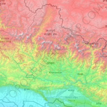
Name: Gandaki Province topographic map, elevation, terrain.
Location: Gandaki Province, Nepal (27.43756 82.87511 29.33125 85.19783)
Average elevation: 2,851 m
Minimum elevation: 87 m
Maximum elevation: 8,121 m
Other topographic maps
Click on a map to view its topography, its elevation and its terrain.
Mount Everest
Nepal > Koshi Province > Solukhumbu
Mount Everest, Khumbupasanglahmu, Solukhumbu, Koshi Province, Nepal
Average elevation: 7,847 m
Japna
Nepal > Karnali Province > Jumla
Japna, Patrasi, Jumla, Karnali Province, Nepal
Average elevation: 2,874 m
Pokhara-16
Nepal > Gandaki Province > Kaski > Pokhara
Pokhara-16, Pokhara, Kaski, Gandaki Province, 60600, Nepal
Average elevation: 1,384 m
Bheri
Nepal > Karnali Province > Jajarkot
Bheri, Jajarkot, Karnali Province, Nepal
Average elevation: 1,397 m
Dharapani
Nepal > Gandaki Province > Manang
Dharapani, Nashong, Manang, Gandaki Province, 33500, Nepal
Average elevation: 2,525 m
Pokhara
Nepal > Gandaki Province > Kaski
Pokhara, Kaski, Gandaki Province, Nepal
Average elevation: 1,203 m
Khumjung
Nepal > Koshi Province > Solukhumbu
Khumjung, Khumbupasanglahmu, Solukhumbu, Koshi Province, 56002, Nepal
Average elevation: 3,888 m
Nilkantha Municipality Ward No. 1
Nilkantha Municipality Ward No. 1, Nilakantha, Dhading, Bagmati Pradesh, Nepal
Average elevation: 1,154 m
Pokhara Lekhnath Metropolitan Ward No. 16
Nepal > Western Development Region > Maidan
Pokhara Lekhnath Metropolitan Ward No. 16, Maidan, Pokhara Lekhnath Metropolitan, Kaski, Gandaki, Western Development Region, 60600, Nepal
Average elevation: 1,228 m
Mount Everest
Nepal > Koshi Province > Solukhumbu
Mount Everest, Khumbupasanglahmu, Solukhumbu, Koshi Province, Nepal
Average elevation: 7,850 m
Changunarayan
Nepal > Bhaktapur > Changunarayan
Changunarayan, Bhaktapur, Bagmati Pradesh, 97701, Nepal
Average elevation: 1,360 m
Kali Gandaki
Nepal > Western Development Region
Kali Gandaki, Baglung, Dhaulagiri, Western Development Region, 063, Nepal
Average elevation: 3,111 m
Krishna Nagar
Krishna Nagar, Krishnanagar, Kapilvastu, Lumbini Province, Nepal
Average elevation: 101 m
Bharatpur Metro
Bharatpur Metro, Bharatpur, Chitwan, Bagmati Pradesh, Nepal
Average elevation: 221 m
Janakpur
Nepal > Province #2 > Janakpur
Janakpur, Dhanusa, Province #2, 110058, Nepal
Average elevation: 81 m
Chilime Khola
Nepal > Central Development Region
Chilime Khola, Rasuwa, Bagmati, Central Development Region, Nepal
Average elevation: 2,388 m
Bharatpur
Nepal > Central Development Region > Bharatpur
Bharatpur, Chitwan, Narayani, Central Development Region, 056, Nepal
Average elevation: 363 m
Chillime
Nepal > Central Development Region > Chillime
Chillime, Rasuwa, Bagmati, Central Development Region, Nepal
Average elevation: 2,194 m
Darling
Nepal > Western Development Region > Darling
Darling, Gulmi, Lumbini, Western Development Region, Nepal
Average elevation: 1,681 m
Koshi
Nepal > Eastern Development Region
Koshi, Eastern Development Region, Nepal
Average elevation: 1,899 m
Western Development Region
Nepal > Western Development Region
Western Development Region, Nepal
Average elevation: 2,421 m
Mardi Himal
Nepal > Western Development Region > Machhapuchhre
Mardi Himal, Machhapuchhre, Kaski, Gandaki, Western Development Region, Nepal
Average elevation: 4,967 m
Daulatpur
Nepal > Eastern Development Region > Daulatpur
Daulatpur, Saptari, Sagarmatha, Eastern Development Region, Nepal
Average elevation: 122 m
Annapurna I
Nepal > Western Development Region > Ghandruk
Annapurna I, Ghandruk, Kaski, Gandaki, Western Development Region, Nepal
Average elevation: 7,127 m
Janakpur
Nepal > Central Development Region
Janakpur, Central Development Region, Nepal
Average elevation: 1,600 m
Lhotse Shar
Nepal > Eastern Development Region > Khumjung
Lhotse Shar, Khumjung, Solukhumbu, Sagarmatha, Eastern Development Region, Nepal
Average elevation: 7,153 m
Central Development Region
Nepal > Central Development Region
Central Development Region, Nepal
Average elevation: 1,546 m
Muna
Nepal > Western Development Region > Muna
Muna, Myagdi, Dhaulagiri, Western Development Region, Nepal
Average elevation: 2,230 m
Mahalangur Himal
Nepal > Eastern Development Region > Makalu
Mahalangur Himal, Makalu, Sankhuwasabha, Koshi, Eastern Development Region, Nepal
Average elevation: 4,695 m
Mahakali
Nepal > Far-Western Development Region
Mahakali, Far-Western Development Region, Nepal
Average elevation: 1,733 m
Karnali
Nepal > Mid-Western Development Region
Karnali, Mid-Western Development Region, Nepal
Average elevation: 4,062 m
Himalayas
Nepal > Eastern Development Region > Khumjung
Himalayas, Khumjung, Solukhumbu, Sagarmatha, Eastern Development Region, Nepal
Average elevation: 7,555 m
Gandaki
Nepal > Western Development Region
Gandaki, Western Development Region, Nepal
Average elevation: 2,842 m
Annapurna II
Nepal > Western Development Region > Parche
Annapurna II, Parche, Kaski, Gandaki, Western Development Region, Nepal
Average elevation: 7,052 m