
Make a donation
Western Development Region topographic map
Click on the map to display elevation.
Make a donation
Western Development Region
The Western Development Region (Nepali: पश्चिमाञ्चल विकास क्षेत्र, Pashchimānchal Bikās Kshetra) was one of Nepal's five development regions. It was located in the west-central part of the country, with its headquarters located in Pokhara. This Development Region was divided into three parts, from south to north in order of increasing altitude: Terai, Hilly and Himalayan. Mustang, Damodar, Peri, Thaple, Ganesh are among the major ranges of the Himalayas.
Make a donation
About this map
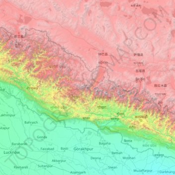
Name: Western Development Region topographic map, elevation, terrain.
Location: Western Development Region, Nepal (26.05710 80.90564 31.25710 86.10564)
Average elevation: 2,742 m
Minimum elevation: 44 m
Maximum elevation: 7,925 m
Make a donation
Other topographic maps
Click on a map to view its topography, its elevation and its terrain.
Make a donation
Bagmati Province
Bagmati Province has an area of 20,300 km2 which is about 13.79% of the total area of Nepal. The elevation of the province ranges from 141 m at Golaghat in Chitwan District to 7,422m at Ganesh Himal. The province has an altitude low enough to support deciduous, coniferous, and alpine forests and woodlands.…
Average elevation: 2,234 m
Make a donation
Make a donation