
Thank you for supporting this site ❤️
Make a donation
Make a donation
Heeresberg topographic map
Click on the map to display elevation.
Thank you for supporting this site ❤️
Make a donation
Make a donation
About this map
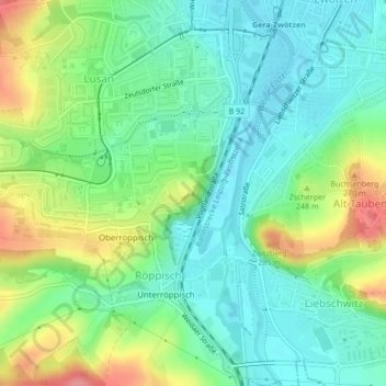
Name: Heeresberg topographic map, elevation, terrain.
Location: Heeresberg, Gera, Thüringen, 07549, Deutschland (50.83794 12.07280 50.83804 12.07290)
Average elevation: 227 m
Minimum elevation: 196 m
Maximum elevation: 289 m
Thank you for supporting this site ❤️
Make a donation
Make a donation
Other topographic maps
Click on a map to view its topography, its elevation and its terrain.
Ferberturm
Deutschland > Thüringen > Gera
Der Ferberturm ist ein 21 Meter hoher Aussichtsturm auf der Ronneburger Höhe in der thüringischen Stadt Gera.
Average elevation: 248 m