
Thank you for supporting this site ❤️
Make a donation
Make a donation
Ferberturm topographic map
Click on the map to display elevation.
Thank you for supporting this site ❤️
Make a donation
Make a donation
Ferberturm
Der Ferberturm ist ein 21 Meter hoher Aussichtsturm auf der Ronneburger Höhe in der thüringischen Stadt Gera.
Thank you for supporting this site ❤️
Make a donation
Make a donation
About this map
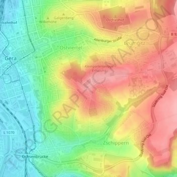
Name: Ferberturm topographic map, elevation, terrain.
Average elevation: 248 m
Minimum elevation: 192 m
Maximum elevation: 302 m
Thank you for supporting this site ❤️
Make a donation
Make a donation
Other topographic maps
Click on a map to view its topography, its elevation and its terrain.
Thank you for supporting this site ❤️
Make a donation
Make a donation
Großaga
Deutschland > Thüringen > Gera
Die schon 1872 bestehende Schützengesellschaft erfuhr 1997 eine Neugründung als Schützengesellschaft Großaga e. V.; jährliche Schützenfeste knüpfen wieder an die alte Tradition an. Seit 1951 gibt es eine Schalmeienkapelle, die weithin bekannt ist. Traditioneller Höhepunkt des Jahres ist das…
Average elevation: 276 m
Thank you for supporting this site ❤️
Make a donation
Make a donation