
Lempira topographic map
Interactive map
Click on the map to display elevation.
About this map
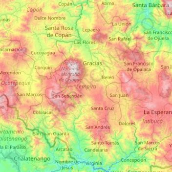
Name: Lempira topographic map, elevation, terrain.
Location: Lempira, Honduras (13.96332 -88.98200 14.94626 -88.31562)
Average elevation: 1,078 m
Minimum elevation: 92 m
Maximum elevation: 2,802 m
Other topographic maps
Click on a map to view its topography, its elevation and its terrain.
San Sebastián
Honduras > Lempira > San Sebastián
San Sebastián, Lempira, Honduras
Average elevation: 1,514 m
Parque Nacional Celaque
Parque Nacional Celaque, Gracias, Lempira, Honduras
Average elevation: 1,759 m
Cerro Las Minas
Cerro Las Minas, Gracias, Lempira, Honduras
Average elevation: 2,531 m